
If your house in New Braunfels has a new crack and your neighbor's never has, you might wonder what you did wrong. Most likely, nothing. New Braunfels sits on two very different kinds of ground, and the line between them runs right through the city. One kind swells and shrinks with every wet spell and dry summer. The other is a thin layer of soil over rock, and it moves far less.
This guide explains which soils sit under New Braunfels, how deep each one goes, what they formed from, and how the nearby towns compare. It also shows you how to look up the soil under your own lot for free, and what each answer means for looking after your house.
About 40% of New Braunfels sits on clay the USDA rates very high for shrink and swell, mostly Branyon and Houston Black, and that clay runs to the bottom of the survey's 80 inches. Another 20% sits on thin, stony soils formed from limestone, with bedrock 13 to 28 inches down. You can check your own lot on the USDA's free Web Soil Survey. On clay, steady moisture matters most. On rock, if something moves, look for water first.
Key facts
- 40% of our 25 USDA sample points in New Braunfels landed on very high shrink-swell clay, and 20% on low or moderate soils.
- Branyon clay stays very high from about a foot down to past 6 feet, with no rock in the top 80 inches.
- Comfort soil has bedrock about 13 inches down, and it formed from limestone.
- Across the launch area, very high clay ranges from 72% of sample points in Converse to none in Canyon Lake.
Why the Line Runs Through New Braunfels
The Bureau of Economic Geology, the state's geological survey, describes Comal Springs in Landa Park as sitting on the boundary of the Edwards Plateau and the Blackland Prairie. The springs rise along the Balcones Fault Zone at the base of a limestone bluff, with harder rock on the western side of the fault.
You can see the same split across Comal County. The Handbook of Texas describes the county's eastern quarter, below the Balcones Escarpment, as gently rolling Blackland Prairie at 600 to 750 feet. The north-western three-quarters rise from 750 to roughly 1,500 feet, with soil that runs from shallow to deep.
The USDA soil survey tells the same story from the ground up. The soils on the rock side formed from weathered limestone. The big clays formed from mudstone, or from clay that old rivers laid down. That's why a short drive can take you from one kind of ground to the other.
Clay or limestone under a slab
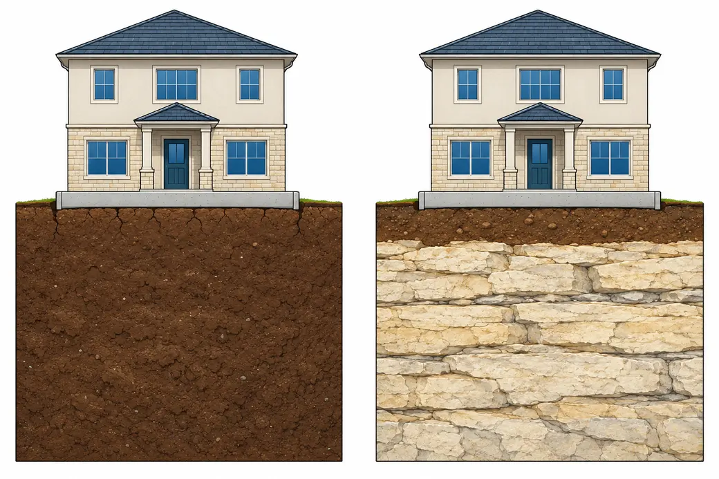
- Deep clay that swells when wet and shrinks as it dries
- Cracks where the clay dries near the surface
- Thin soil under the other house
- Limestone rock close below the slab
How Soil Movement Is Measured
The USDA puts a number on swelling. It's called linear extensibility, and it's the percent a sample of soil grows in length from fully dry to moist. Every soil in the survey falls into one of four bands:
- Under 3: low
- 3 to 6: moderate
- 6 to 9: high
- 9 or more: very high
The survey's own guidance says soils rated moderate to very high can damage buildings and roads as they shrink and swell.
Picture a dry lump of Branyon clay 10 inches long. Soak it, and it grows to 11.3 inches. The same lump of Comfort soil would reach only about 10.3. A lab dries soil far more than any Texas summer will, so use the number to compare soils, not to predict how far your house will move.
The Clay Side: Branyon, Houston Black and Heiden
We checked the USDA survey at 25 points spread across New Braunfels. These three clays turned up at 40% of them, and all three rate very high.
Branyon is the city's most common soil, at 20% of our points. Its top foot reads 9.9, already very high. Below that, it reads 13.0 and stays there past 6 feet, with 53% clay. The survey finds no rock in the top 80 inches. Branyon formed from clay that rivers laid down long ago, and the survey maps it on nearly flat ground.
Houston Black covers 12% of our points. It reads 12.0 from the surface all the way down, with 54% clay, so there's no calmer layer below it for a slab to rest on. It formed from weathered mudstone.
Heiden covers 8%. It reads 12.1 to 12.2 down to about 58 inches, then 10.0 below that. It also formed from mudstone, and it's mapped on gentle slopes.
What these three share is depth. A slab on any of them rests on a thick bed of clay that grows and shrinks as its moisture changes, and you won't reach the bottom of it with a shovel.
The Limestone Side: Comfort and Rumple
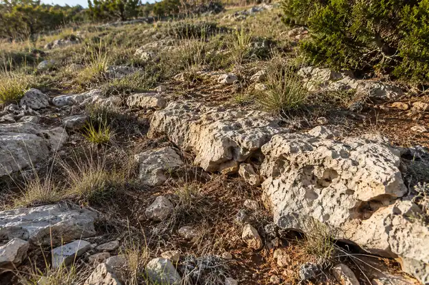
Comfort covers 8% of our points, and it's a very different soil. It's very stony clay, and only about 13 inches deep before the survey hits bedrock. It reads 3.2 at most, in the moderate band. The survey maps it alongside bare rock outcrop, which makes up 15% of that map unit, and lists the outcrop as limestone.
Rumple covers another 12%. It's a gravelly, cobbly soil that reads 4.4 at most, with bedrock about 28 inches down. It formed from limestone too.
A house on these soils has far less ground beneath it to swell and shrink. So if a house on the rock side does move, shrink and swell probably isn't the main cause. It's worth looking for a plumbing leak, a spot where roof water lands, or poor grading first.
One caution: the survey describes the natural ground. If your lot was leveled with soil brought in from somewhere else, the survey won't show it.
In Between: Lewisville
Lewisville silty clay covers 12% of our points. It reads 7.5, in the high band, from the surface to about 5 feet down. It moves less than Branyon or Houston Black, but it still moves, so it calls for the same care as the clay side.
The other 28% of our New Braunfels points landed on a mix of less common soils.
Town by Town Around New Braunfels
The split doesn't stop at the city limits. Here's the share of our USDA sample points on very high shrink-swell clay in each town we cover today, with its most common soils:
- Converse: 72%, mostly Houston Black (52%)
- Universal City: 52%, Houston Black (20%) and Heiden (16%)
- Live Oak: 48%, Houston Black (32%)
- San Marcos: 48%, though Comfort (28%) is its most common soil
- Kyle: 48%, though Real (20%), a low soil, is its most common
- Cibolo: 44%, Houston Black (24%) and Branyon (20%)
- New Braunfels: 40%, Branyon (20%)
- Seguin: 40%, all of it Branyon
- Garden Ridge: 28%, with Comfort (24%) most common
- Schertz: 20%, Branyon and Lewisville at 20% each
- Selma: 12%, Lewisville (16%)
- Canyon Lake: none, mostly Brackett (52%), with bedrock about 14 inches down
Look closely at San Marcos, Kyle and Garden Ridge. Each has a rock-side soil as its most common one, and each still has plenty of very high clay. They're mixed towns, not rock towns, so two houses a few streets apart can sit on very different ground.
The same soil can read differently from town to town, too. Houston Black reads 12.0 on most of the survey's maps around New Braunfels, but 17.0 in Selma. Both are well inside the very high band. Each town's page has its own full breakdown.
How to Look Up the Soil Under Your Lot
The USDA's Web Soil Survey is free, and you don't need to know anything about soil to use it.
Start it up. Go to websoilsurvey.nrcs.usda.gov and choose "Start Web Soil Survey."
Go to your address. In the Quick Navigation panel on the left, choose "Address," enter yours and press "View." On a phone in your own yard, "Latitude and Longitude or Current Location" will find you instead.
Mark your lot. Use the rectangle tool in the bar above the map to draw a small box over your house and yard. That box is what the survey calls your area of interest.
Open the Soil Map tab. You'll see a list of the soil names inside your box. The first word of each name tells you most of what you need. A name that starts with Branyon, Houston Black or Heiden puts you on the clay side. One that starts with Comfort, Rumple or Brackett puts you on the limestone side.
Around New Braunfels, the survey area is usually "Comal and Hays Counties, Texas." Seguin falls under "Guadalupe County, Texas."
Keep in mind that the survey maps areas, not single lots. The USDA itself says some engineering uses need a check on site. If you need a firm answer for one house, that means a soil test by an engineer.
What Your Soil Means for Your House
The soil is what it is. What you can control is how much its moisture rises and falls. The Post-Tensioning Institute says a slab's long-term performance depends on good drainage and on the owner keeping the soil moisture steady.
- On Branyon, Houston Black or Heiden, even moisture all the way around the house is the goal. Send roof water well away from the walls, keep the ground sloping away from the slab, and water the foundation evenly through a dry summer. New Braunfels Utilities' rules allow foundation watering even in Stage 2.
- On Lewisville, follow the same routine. It's a little more forgiving, but it still rewards steady moisture.
- On Comfort, Rumple or Brackett, look for water first if something moves: a leak under the slab, roof water landing in one spot, or a low corner.
When someone inspects your foundation, ask which soil they think is under it. Branyon at 13.0 and Comfort at 3.2 point to very different causes. A foundation inspection measures what the house is doing, and the soil helps explain why.
New Braunfels Soil Questions
Is all of New Braunfels on expansive clay?
No. In our sample, 40% of the city sat on very high shrink-swell clay, mostly Branyon and Houston Black. But 20% sat on Comfort and Rumple, thin soils over limestone that read 4.4 or less.
How deep does the clay go?
On the clay side, as deep as the survey looks. Branyon and Houston Black both stay very high past 6 feet, with no rock in the top 80 inches. Heiden stays very high to about 58 inches. On the limestone side, the rock sits about 13 inches under Comfort and 28 inches under Rumple.
Is limestone ground safe to build on?
It's far steadier than deep clay, because there's so little soil to swell and shrink. That doesn't make a house on rock immune to trouble. A leak or poor drainage can still move a slab.
Can I find out what soil is under my house?
Yes, for free. Search your address on the USDA's Web Soil Survey, draw a box over your lot and read the Soil Map tab. It shows the soil for the area, so an engineer's soil test is the way to be sure about one house.
Does clay soil mean my house will need repair?
No. Clay is only half the story. What moves a house is moisture changing unevenly under it, and drainage, steady watering and fixing leaks early all help a lot, even on Branyon. If you're already seeing signs, a free inspection is a good place to start.